BRIC AND BROOKLYN HISTORICAL SOCIETY PRESENT MAPPING BROOKLYN, AN EXHIBITION JUXTAPOSING HISTORIC MAPS WITH MAPPING-THEMED WORKS BY CONTEMPORARY ARTISTS
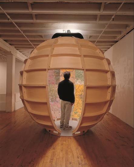
Artist Joyce Kozloff’s nine-foot diameter walk-in globe, painted with aerial maps of sites involved in U.S. military warfare, is part of the upcoming “Mapping Brooklyn” exhibition. Photo courtesy of BRIC
On view at BRIC House (647 Fulton Street, Downtown Brooklyn): February 26 – May 3 Opening
Reception: Wednesday, February 25, 7 – 9pm
On view at Brooklyn Historical Society (128 Pierrepont Street, Brooklyn Heights): February 26 – September 6
BRIC and Brooklyn Historical Society (BHS) are pleased to co-present Mapping Brooklyn, a new exhibition featuring contemporary art works that use mapping and cartography as themes alongside actual historic maps. Curated by Elizabeth Ferrer, Vice President of Contemporary Art at BRIC, and spanning the galleries at BRIC House (647 Fulton Street) and Brooklyn Historical Society (128 Pierrepont Street), Mapping Brooklyn explores the myriad ways that maps can represent practical matters such as wayfinding, property ownership, population shifts and war strategy, while also navigating the metaphorical, the psychological and the personal. At both venues, historic maps and contemporary works will be in dialogue, suggesting common themes—the desire to explore, chart, and analyze territory—and highlighting the innovative ways that contemporary artists use mapping, cartography and exploration, to reveal data, ideas and emotions. The historic maps will be drawn from BHS’s collection, one of the richest collections of maps of Brooklyn in the world. Included are fire insurance maps, transportation maps, demographic maps and nautical charts, among others. A colorful pictorial road map to the 1939 New York World’s Fair, a commercial edition of a Red Scare-era map depicting enclaves of suspected radical activity, and a detailed map of one of Brooklyn’s earliest botanic gardens, showing plots of exotic plants and fruits, are among the dozen or so maps and atlases on display.
“We are thrilled to be partnering with BRIC on this fascinating study of how maps can influence art and self expression,” said Deborah Schwartz, President of Brooklyn Historical Society. “This exhibition not only allows us to share the wide range of historic maps in our collection, it also places these technical documents in a contemporary context to reveal their influence over universal ideas like the need to belong, the desire for representation, and the constantly changing nature of the borough and the world around us.”
Artworks will range widely in scale and medium, including painting, photography, drawing, sculpture, installations, interactive projects, and appropriated and manipulated historic and contemporary documents. Many of the artists have conducted research into the BHS map collection and have selected the historic maps that will be shown alongside their work. Participating artists include Aaron Beebe, Daniel Bejar, Francisca Benitez, Gail Biederman, Justin Blinder, Christine Gedeon, Katarina Jerinic, Joyce Kozloff, Laura Kurgan, Peter Lapsley, Jennifer Maravillas, Simonetta Moro, Bundith Phunsombartlet, Jan Rothuizen, Patricia Smith, Nick Vaughan & Jake Margolin, and Sarah Williams.